

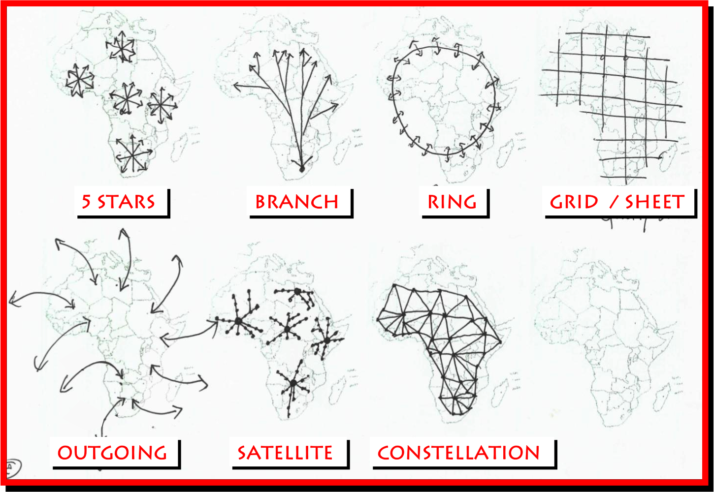
The purpose of the project was to discuss conceptual alternative scenarios for the spatial development of the African continent in light of NEPAD. Annemarie's role was to translate conceptual discussions graphically and the map illustrates the potential spatial concepts for the development of Africa. The graphic is purely conceptual and was created by hand.
Acknowledgements: CSIR
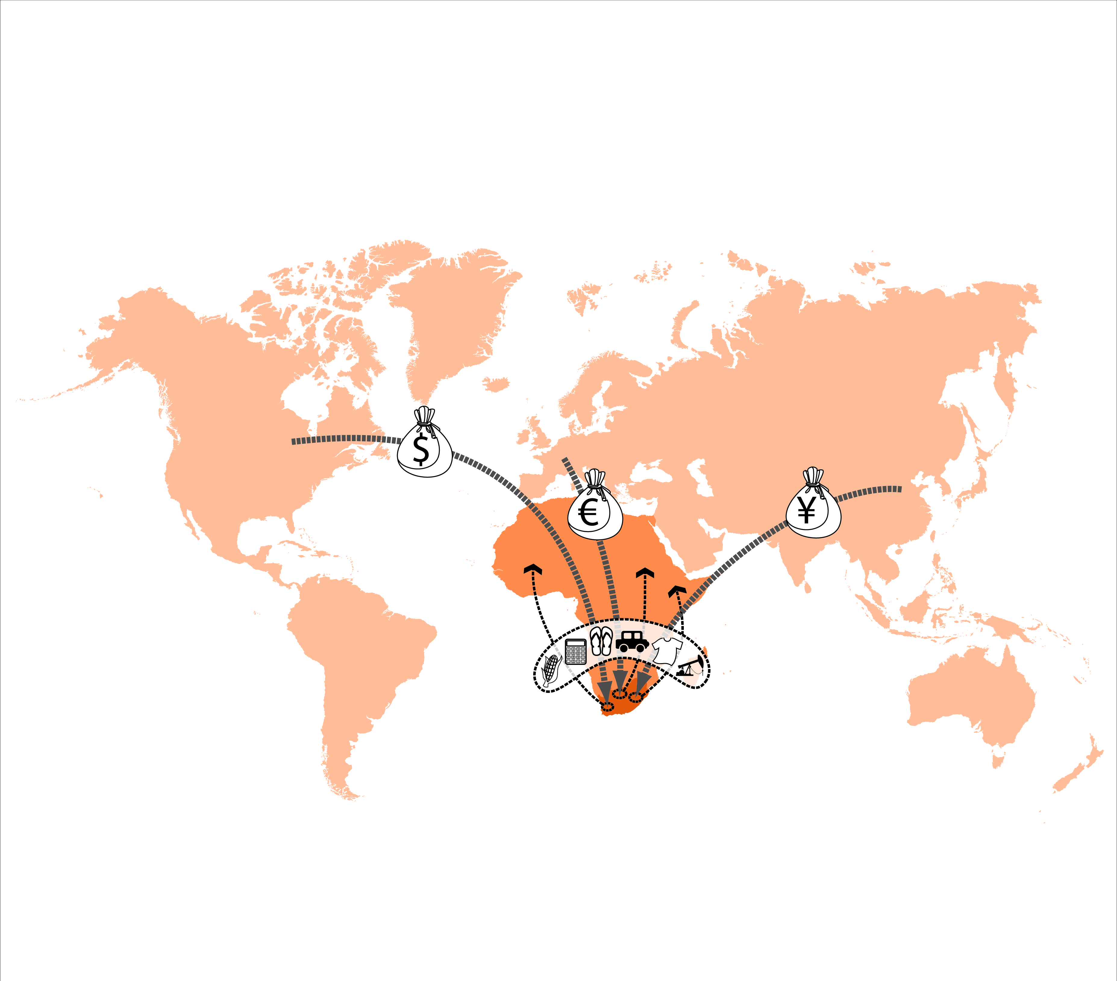
The purpose of the project was to develop a Functional Regions Spatial Development Perspective of South Africa for the Economic Development Department. Annemarie's role was to present spatial data through conceptual spatial graphics. The map illustrates the potential outflow of products and inflow of foreign exchange into South Africa. The graphic is based on economic data generated through the project, though the illustration is purely conceptual.
Acknowledgements: CSIR & EDD

The purpose of the project was to develop a Functional Regions Spatial Development Perspective of South Africa for the Economic Development Department. Annemarie's role was to present spatial data through conceptual spatial graphics. The map illustrates places where a significant contribution towards national job creation targets in infrastructure can potentially be made in the short term. The graphic is based on economic and spatial GIS data generated through the project.
Acknowledgements: CSIR & EDD
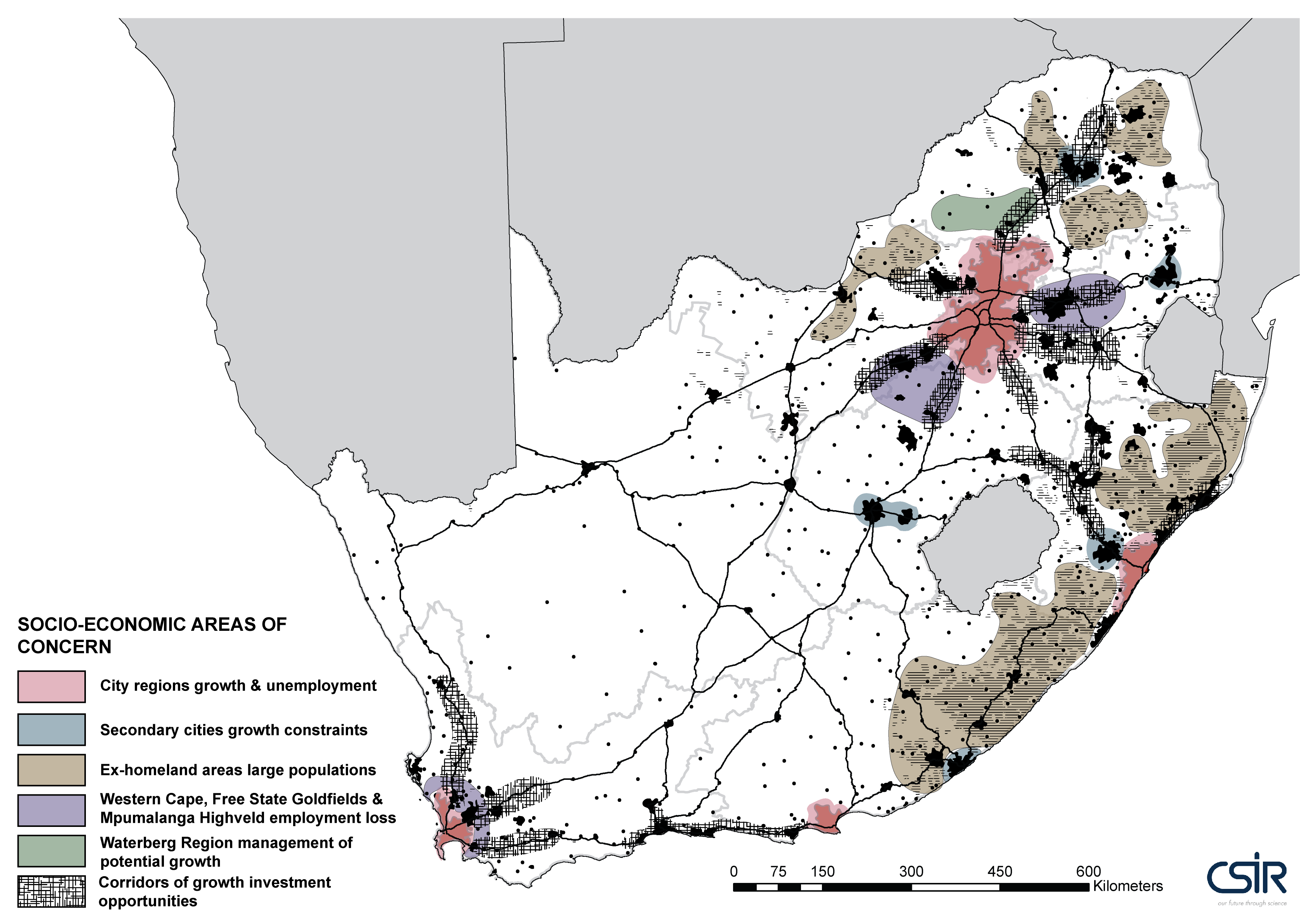
The purpose of the project was to present spatial trends with regard to development for the National Planning Commission (NPC). Annemarie's role was to present spatial data through conceptual spatial graphics. the map illustrates places that present social areas of concern for the development of the country. The graphic is based on economic and spatial GIS data generated through the project.
Acknowledgements: CSIR & NPC
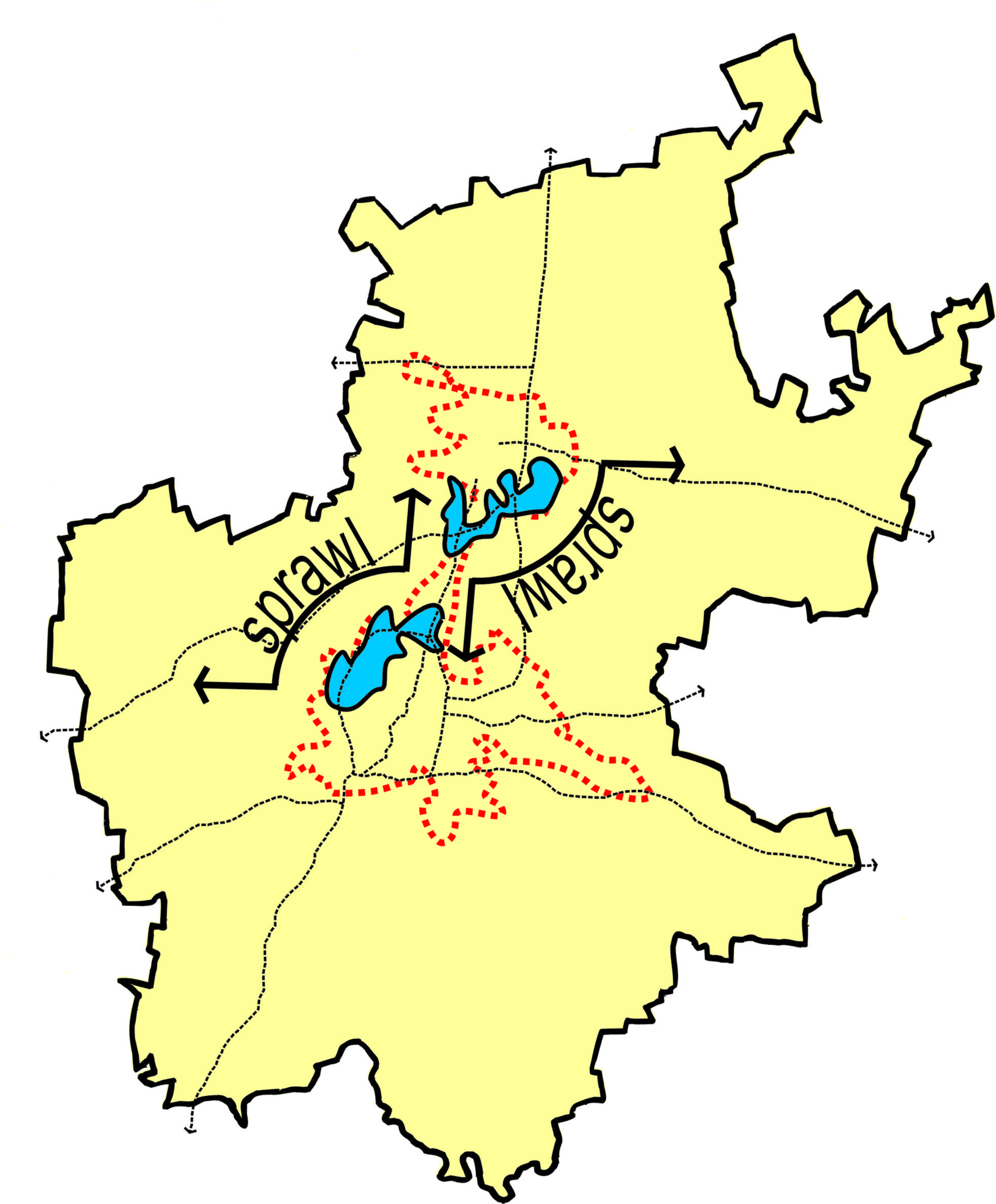
The purpose of the project was to develop a spatial development framework for the development of Gauteng. Annemarie's role was to present spatial data through conceptual spatial graphics. The map illustrates the areas of urban sprawl experienced in Gauteng. The graphic is based on economic data generated through the project, though the illustration is purely conceptual.
Acknowledgements: CSIR
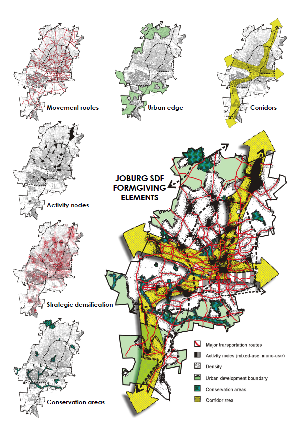
The purpose of the project was to develop a spatial development framework for Johannesburg (2005). Annemarie's role was to illustrate conceptual ideas through graphics. The map illustrates the formgiving elements for the development of Joburg as part of a spatial vision for the spatial structure of the city structure. The illustration is conceptual, although the specific localities of elements (roads, nodes, etc.) are geographically accurate. The graphics were created on CorelDraw.

The Alaska Fire Management Project was conducted between July and November 2015. With a focus on shack fires in the informal settlement of Alaska (in Mamelodi East, Pretoria), the project used ArcGIS software to establish the response time and analyse risk associated with municipal firefighting services.
The purpose of this map is to show the fire-spreading risk of each dwelling in the Alaska informal settlement based on shack density and tap distribution. Dwellings in red represent high fire-spreading risk, dwellings in orange represent medium fire-spreading risk, and dwellings in yellow represent low fire-spreading risk. Areas where dwellings are highly clustered without any water taps in close proximity were considered to be higher risk areas based on their fire-spreading risk. These areas would be recommended as areas to build new water infrastructure in order to provide settlement-wide water distribution to fight fires.
Very limited data are available for the study area in the Alaska informal settlement, the only data being outdated City of Tshwane aerial photographs taken of the area in 2012. It was therefore necessary to start the project with three data-capture field trips, conducted on 23 July 2015, 30 July 2015 and 6 August 2015. The data collection was conducted by the third-year GMT 320 Geoinformatics students at the University of Pretoria. Tap points and dwelling point location data were captured using GPS handheld devices, and the Epicollect mobile application was used to capture corresponding attribute data.
The data were analysed and mapped using ArcGIS. This map is one of a collection of four maps created for the project.
Comments on how map can be used:
Shack fires still pose an enormous threat to the safety of millions of South Africans living in informal settlements every day. The innovative uses of GIS are playing an increasing role in making the lives of poor South Africans better. With advances in web and mobile GIS applications, spatial information is being ever more accessible by people who never had access to it before. Through the creative use of these technologies, GIS can be used to make the lives of people living within informal settlements safer.
As part of the overall project, four hard-copy maps were produced for the project using ArcGIS and handed over to the Viva Foundation of South Africa (an NGO serving the community) on 20 October 2015. The purpose of the hard-copy maps was that they could be used by the community and the Viva Foundation of South Africa to gain a better understanding of the layout of the Alaska informal settlement, as well as the risk posed by potential fire disasters. A secondary use for the maps would be educational.
The project deliverables, including the maps, are accessible through the project website: http://mamelodimappers.wix.com/alaska-fire-project
Map reference: Arnold, K. (2016, forthcoming). Shack density and tap distribution of Alaska Informal Settlement, Mamelodi East (July/August 2015), 1:3500. Esri User Conference, 27 June – 1 July 2016, San Diego, CA.
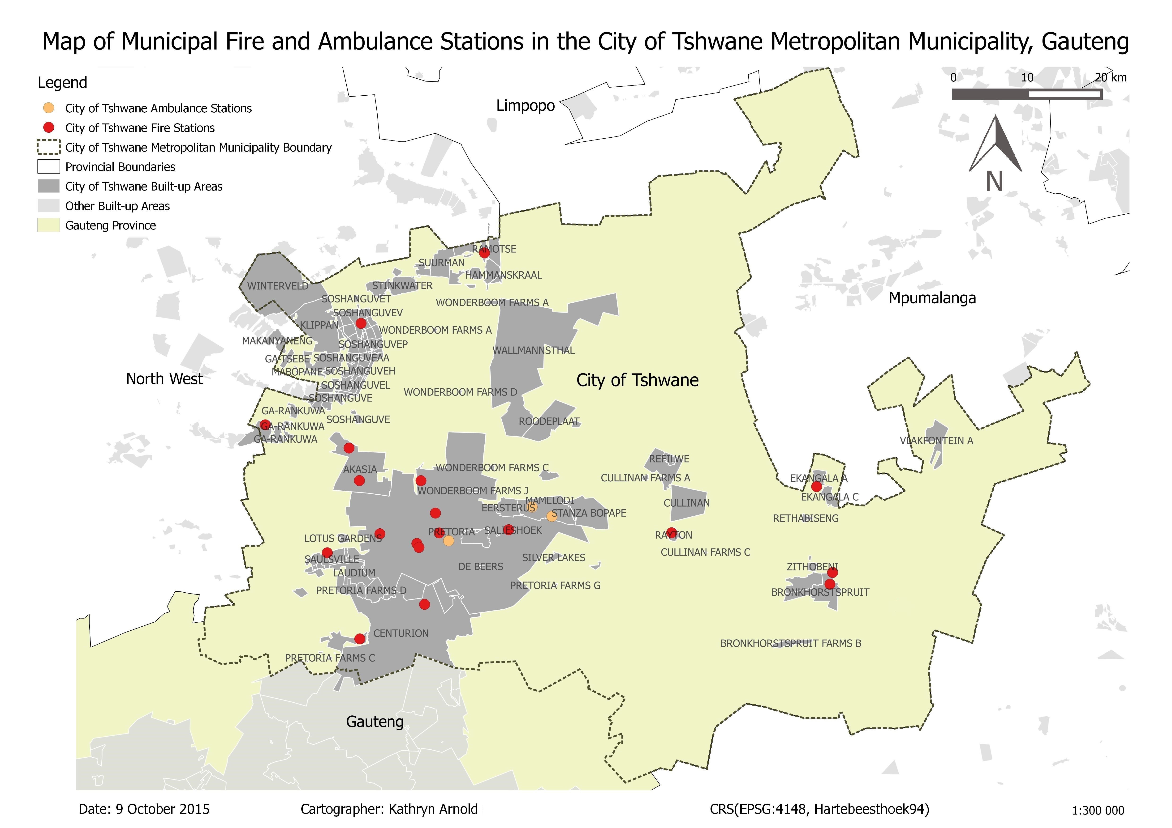
The Alaska Fire Management Project was conducted between July and November 2015. With a focus on shack fires in the informal settlement of Alaska (in Mamelodi East, Pretoria), the project used QuantumGIS (QGIS) software to establish the response time and analyse risk associated with municipal firefighting services.
The purpose of this map is to show the locations and distribution of fire and ambulance stations within the City of Tshwane, in relation to major built-up areas in the municipality. The data were analysed and mapped using QGIS software. This map is one of a collection of four maps created for the project.
The only data regarding Tshwane fire and ambulance stations was found on the City of Tshwane web page (CoT, 2015). This page gives information on the fire and ambulance stations in Tshwane, including the station name, the services conducted by the station and the physical address. In some cases, only street names were given without any coordinates.
In order produce the City of Tshwane Fire and Ambulance Station dataset, it was necessary to create attribute and coordinate data that could be used for analysis. The following steps were followed:
References: CoT (City of Tshwane). 2015. Fire and Ambulance Stations. [Online] Available at: http://www.tshwane.gov.za/sites/residents/Services/FireBrigade/Pages/Fire-and-Ambulance.aspx. Accessed: 13 August 2015.
Comments on how the map can be used:
Shack fires still pose an enormous threat to the safety of millions of South Africans living in informal settlements every day. The innovative uses of GIS are playing an increasing role in making the lives of poor South Africans better. With advances in web and mobile GIS applications, spatial information is being ever more accessible by people who never had access to it before. Through the creative use of these technologies, GIS can be used to make the lives of people living within informal settlements safer.
As part of the overall project, four hard-copy maps were produced for the project using QGIS and handed over to the Viva Foundation of South Africa (an NGO serving the community) on 20 October 2015. The purpose of the hard-copy maps was that they could be used by the community and the Viva Foundation of South Africa to gain a better understanding of the layout of the Alaska informal settlement, as well as the risk posed by potential fire disasters. A secondary use for the maps would be educational.
The project deliverables, including the maps, are accessible through the project website: http://mamelodimappers.wix.com/alaska-fire-project
Map reference: Arnold, K. (2015). Map of municipal fire and ambulance stations in the City of Tshwane Metropolitan Municipality, Gauteng, 1:300000. University of Pretoria.
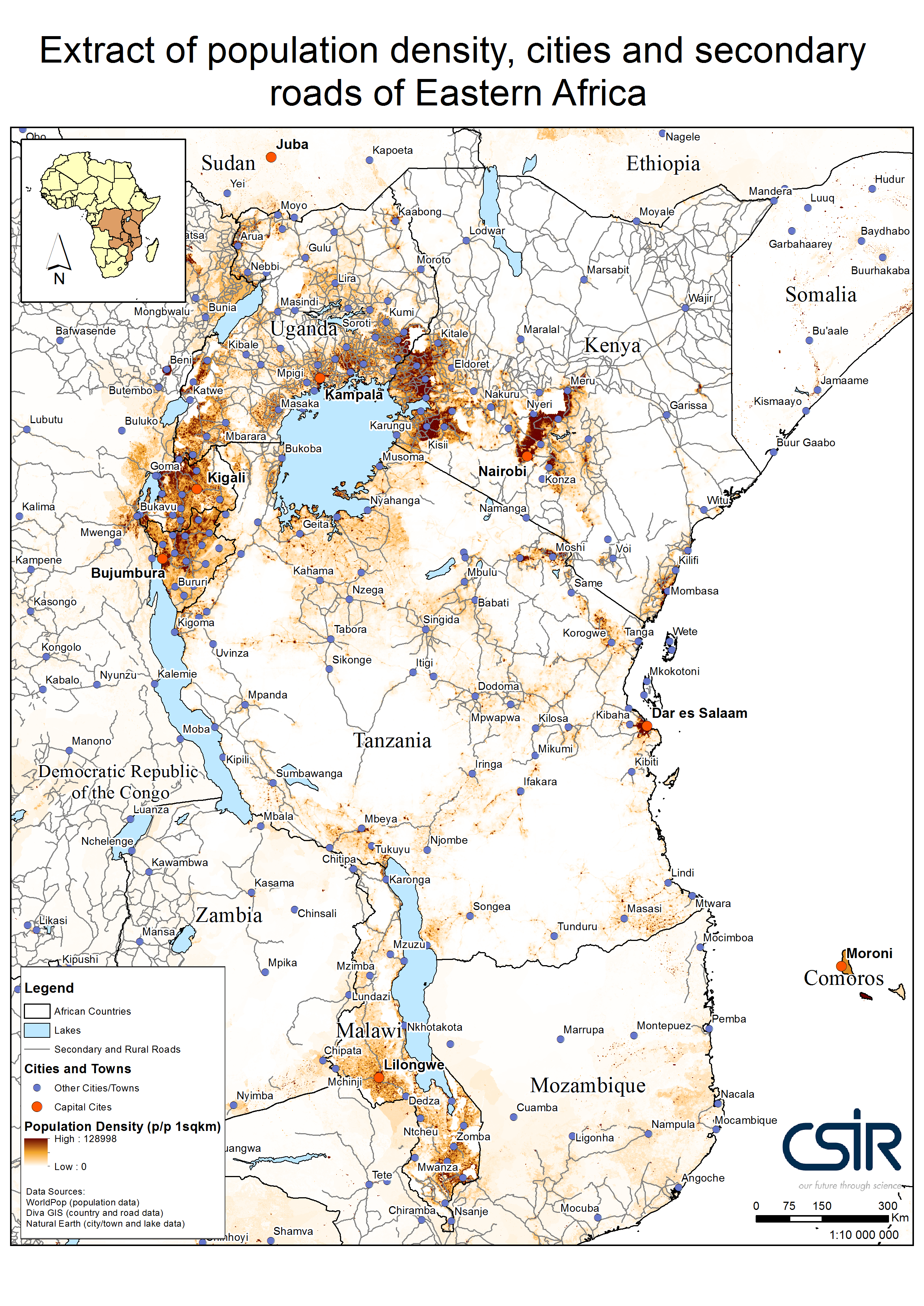
The purpose of this map is to show the relationship between the population densities of countries in East Africa and the locations of the African Great lakes. The key message of the map is to show the extent to which major water sources influence population density and hence transport networks.
Given that only 34 percent of rural Africans live within two kilometres of an all-season road (African Monitor, 2012), the development of rural infrastructure had an important role to play in poverty alleviation (Torero & Chowdhury, 2005). The map therefore establishes the baseline of the existing secondary road network in East Africa.
A number of data sources were used. Population data were sourced form WorldPop, country; road data from Diva GIS; and city and lake data from Natural Earth.
References: African Monitor. (2012). Rural infrastructure in Africa: Unlocking the African moment. Development Support Monitor, Paper series No. 1. [Online] Available at: http://www.africanmonitor.org/assets/files/Publications/Rural%20Infrastructure%20In%20Africa.pdf. Accessed: 10 May 2016.
Torero, M. & Chowdhury, S. (2005). Increasing access to infrastructure for Africa’s rural poor. International Food Policy Research Institute, 2020 Africa Conference Brief, Workshop 16.
Comments on how the map can be used:
By establishing the baseline of the existing secondary road network in East Africa, the map can be used to consider future infrastructure project in relation to population density and the alternative opportunities offered by water transport on the lakes.
The map was created using ArcGIS software. A number of data sources were used. Population data were sourced form WorldPop, country; road data from Diva GIS; and city and lake data from Natural Earth.
Map reference: Arnold, K. (2016). Extract of population density, cities and secondary roads of Eastern Africa, 1:10 000 000. CSIR: Pretoria.
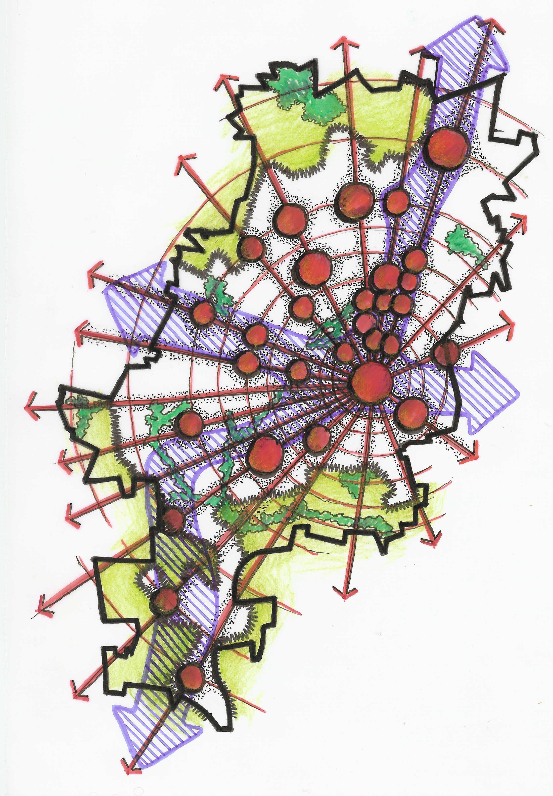
The purpose of the project was to provide a spatial development framework for Johannesburg (2005). Annemarie's role was to illustrate conceptual ideas through graphics. The map illustrates the conceptual growth of Joburg. The graphic is purely conceptual.
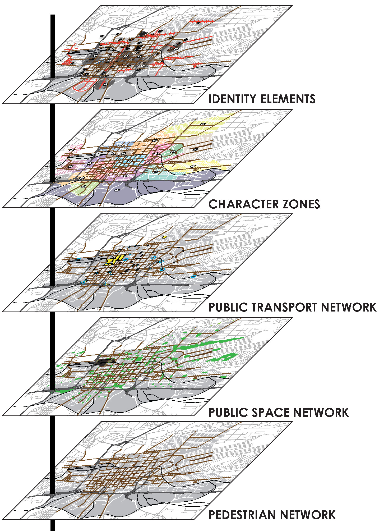
The purpose of the project was to develop an urban design implementation plan for the inner city of Johannesburg. The map illustrates the layers of the various formgiving elements for the development of the inner city. The maps are in essence GIS based, but the final maps and graphics were generated with Illustrator.
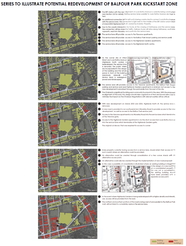
The purpose of the project was to develop a development framework for the transformation of a traditionally suburban ares into a fully functional TOD precinct around two BRT stations. The map illustrates the potential redevelopment of the area through time with a series of aerial photo-based maps and descriptions. The maps were generated with Illustrator.